
Museum of Palestinian Memory
Palestinian Districts
Gaza District
The Gaza Strip lies along the southwestern border of Palestine, along the coast of the Mediterranean Sea, and northeast of the Sinai Peninsula of Egypt. It is one of two discreet areas of Mandatory Palestine (the other being the West Bank along the River Jordan) which were not occupied by Zionist forces in 1948. Thus, it did not become part of the nascent State of Israel. The Gaza Strip comprises about 1.33% of the area of Palestine. Its largest city is Gaza City. Israel borders the Gaza Strip to the north and east, while Egypt borders it to the south.

(map – Qada’ Gaza)
Home to a little over two million Palestinians, the Gaza Strip’s population density is very high, similar to that of Hong Kong. Its annual population growth is 1.99% (2023 est.), ranking it the 39th highest in the world. The majority of Palestinians (about 70%) are descendants of refugees who either fled or were expelled from the parts of Palestine that were occupied by Zionist forces in 1948. There are eight refugee camps in the Gaza Strip. Sunni Muslims make up the majority of the population, and there is a minority Christian community.
The Gaza Strip and the West Bank were, together, the territory within which the Palestinian Authority (PA) sought to establish an independent state, after more than 30 years of negotiations stemming from the Oslo Accords, which called for a two-state solution to the conflict in Palestine. Both were nominally under the control of the Palestinian Authority until 2007. In 2006, Hamas won elections against the PA. However, the PA continued to govern the West Bank, while Hamas took over the government in Gaza.
Geography, Geology, and Climate

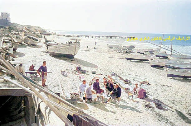
(picture – the sea at Gaza)
The Gaza Strip is 41 kms. long and its width ranges between six to 12 kms.; its total area is 365 square kms. Its border with historic Palestine is 51 kms. long, and it shares an 11-km. long border with Egypt near the Palestinian city of Rafah. Other major cities in Gaza include Khan Younis, located seven kilometers north of Rafah; Gaza City, which is centrally-located; Deir al-Balah lies along the coast between Rafah and Gaza City; Beit Lahiya and Beit Hanoun are located to the north and northeast of Gaza City, respectively. Deira Beach is a favorite destination for surfers. The Gush Katif block of Israeli occupation was located on the sand dunes adjacent to Rafah and Khan Yunis, along the southwestern edge of the 40 km. coast of the Mediterranean Sea, before it was dismantled in 2005.
The topography of the Gaza Strip is dominated by three hills parallel to the coast, consisting of ancient pleistocene limestone (deposited by the wind). They are together referred to as “Karkar”, and are interspersed with fine, granular red fossil soil referred to as “red”. The three hills are separated by valleys filled with alluvial sediments. The terrain is either flat or rolling, with sand dunes located near the coast. The highest point in the Gaza Strip is Abu Odeh, which stands at 105 meters above sea level. The main river in the Gaza Strip is Wadi Gaza, and the Wadi Gaza Nature Reserve was established around it to protect the only coastal wetlands in the Strip.
The Gaza Strip is characterized by a hot, semi-arid climate with warm winters and relatively dry, hot summers. Despite the drought, humidity is high throughout the year. Average annual rainfall ranges from 225 mm. (9 in.) in the southern regions, to 400 mm. (16 in.) in the north, with the majority of rainfall occurring between November and February. The region faces many environmental challenges, including desertification, freshwater salinity, wastewater treatment, waterborne diseases, soil dredging, and pollution and depletion of groundwater resources.
Early History of Gaza
The oldest major settlements in the area were found at Tell al-Sakan and Tell al-Ajal, two Bronze Age settlements that served as administrative sites for ancient Egyptian rule. Gaza City had already existed under Palestinian rule, and in 332 BC, Alexander the Great captured the city during his Egyptian campaign. After Alexander’s death, Gaza and Egypt came under the administration of the Ptolemaic dynasty, before passing to the Seleucid dynasty around 200 BC.
Gaza City was destroyed by the Hasmonean king and Jewish high priest Alexander Janeius in 96 BC, but re-established under Roman administration during the first century AD. The geographical area that currently makes up the Gaza Strip underwent several transfers between different Roman provinces over time, including from Judea, to Syria Palestine, and finally to First Palestine. During the seventh century, the region’s governance was moved back and forth between the Eastern Roman (Byzantine) and the Persian (Sassanid) Empires, before the establishment of the Rashidun Caliphate during the major Islamic expansions of the seventh century.
British Mandate, 1918 – 1948
Upon the dismemberment of the Ottoman Empire, as a result of World War I, the Gaza Strip came under British occupation from 1918 – 1948. The British Mandate for Palestine was based on the principles contained in Article 22 of the draft Charter of the League of Nations, and the San Remo Resolution of 25 April 1920, which was drafted by the main Allied and associated powers after World War I. The Mandate formalized British rule in the southern part of Ottoman Syria from 1923 to 1948 (Amal: which modern day countries would this include?)
All-Palestine Government, 1948 – 1959
When the British Government announced its intention to end its Mandate over Palestine in 1948, the Gaza Strip came under the control of the Egyptian Government. As a result of the 1948 – 1949 Palestine War, 25% of Palestinians were forced to flee from the main area of Historic Palestine into the Gaza Strip, although it only constituted 1% of the entire land area of Palestine. As hostilities drew to a close, the United Nations Relief and Works Agency (UNWRA) was established to manage various refugee programs.
On 22 September 1948, as hostilities receded, the All-Palestine Government was declared in Gaza City; it was under Egyptian control, under the auspices of the Arab League. It was partly conceived as an attempt by the Arab League to limit the influence of Transjordan (now Jordan) in Palestine. The All-Palestine Government was soon recognized by six of the seven members of the Arab League: Egypt, Syria, Lebanon, Iraq, Saudi Arabia, and Yemen, but not by Transjordan. It was not recognized by any country outside the Arab League.
After the cessation of hostilities, the armistice agreement between Israel and Egypt, signed on 24 February 1949, determined the demarcation line between Egyptian and Israeli forces. It also defined what has come to be recognized as the border between the Gaza Strip and Israel.
Article V of this Convention declared that the demarcation line should not be considered a permanent international border. What is recognized as the international border between Egypt and the Gaza Strip is the same that was initially established in 1906 between the Ottoman and the British Empires.
1956 Massacres: During the Suez Crisis of 1956, Israel invaded the Gaza Strip as well as the Egyptian Sinai Peninsula. Khan Yunis resisted and Israel responded with an intensive bombing campaign that inflicted heavy civilian casualties. On 3 November, the city fell and the Israeli army embarked on a massacre, killing hundreds of Palestinians, most of them civilians. In one horrific incident, men were lined up in front of walls in the central square and executed with machine guns. On 12 November, days after the hostilities were declared ended, Israeli forces killed 111 people in the Rafah refugee camp, drawing international criticism.
Egyptian Administration, 1959-1967
After the dissolution of the All-Palestine Government in 1959, and under the pretext of Arab nationalism, Egypt continued to administer the Gaza Strip until 1967. Gaza was never officially annexed, but was treated as a controlled area and administered through a military governor. More than 200,000 refugees had fled to Gaza, or were forcefully expelled from their homes, during the 1948 Arab-Israeli war. This led to a significant decline in the standard of living. Due to restrictions imposed by the Egyptian government on movement to and from Gaza, all residents experienced significant challenges in their ability to search elsewhere for gainful employment.
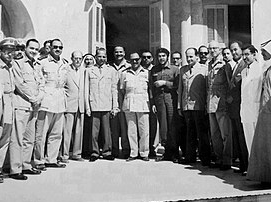
(صورة تشي جيفارا في غزة)
Israeli Occupation, 1967 to present
During the June 1967 war, Israel took control of the Gaza Strip. It established Israel’s first settlement bloc in Gaza, Gush Katif, in the southwestern corner near Rafah and the Egyptian border. The same site was once home to a small kubutz that had existed for 18 months between 1946 and 1948. In total, between 1967 and 2005, Israel established 21 settlements in Gaza, occupying 20 percent of the land area of Gaza.
According to Tom Segev, the possibility of relocating the Palestinian population out of the Gaza Strip was a constant focus of Zionist thinking back to earlier eras (22). During a December 1967 meeting of the Israeli security cabinet, the question of what to do with the Arab population in the newly occupied areas was discussed. Prime Minister Levi Eshkol suggested that one way to encourage Palestinians to leave Gaza might be to restrict their access to water. “Maybe if we don’t give them enough water, they have no other choice,” he was quoted as saying. Following this meeting, a series of measures, including financial incentives, were implemented to encourage Gazans and refugees to migrate out of the Gaza Strip. (22)
Peace Treaty between Egypt and Israel, 1979: On 26 March 1979, Israel and Egypt signed the Egyptian-Israeli Peace Treaty. One of the provisions stipulated that Israel would withdraw its armed forces and civilians from the Sinai Peninsula, which Israel had occupied during the June 1967 War. A 100-meter-wide buffer zone was established between Gaza and Egypt known as the Salah al-Din Axis. The length of the international border along the Philadelphia Corridor. (? – is this the same as the Salah al-Din Axis? It hasn’t been mentioned before) is seven miles.
The Egyptians agreed to demilitarize the Sinai Peninsula, and it renounced all territorial claims to the territory north of the agreed-to border. The final status of the Gaza Strip and other relations between Israel and the Palestinians were not addressed in the treaty. The Gaza Strip remained under Israeli military administration, and the Israeli army became responsible for the maintenance of civilian facilities and services.
As part of the Oslo accords signed in 1993, Israel granted limited autonomy to the Palestinian Authority in Gaza. Since 2007, the Gaza Strip has been effectively ruled as a one-party state by Hamas. Israel unilaterally withdrew its military forces from Gaza and dismantled it Israeli settlements in 2005. However, since the Israeli military continues to control Gaza’s borders, airspace, and sea ports, the United Nations, the International Committee of the Red Cross, and several human rights organizations consider it to still be occupied, despite Israel’s “disengagement”. Due to the blockade which Israel imposed after the elections in 2007, Gaza has continued to suffer from shortages of water, electricity, and medicine. The United Nations, along with at least 19 human rights organizations, has urged Israel to lift its blockade of Gaza. Israel has reserved the right to enter Gaza at will with its army, and maintains a restricted buffer zone between it and Gaza inside the Gaza Strip. Gaza also relies on Israel for virtually all its water, electricity, telecommunications, and other utilities.

(pic – Beit Hanoun area of Gaza in August, 2014, after Israeli shelling)
(Amal, will there be more recent history of Gaza, including repeated Israeli bombardment of Gaza? There should be some context for the picture above.)